ST. JOHN'S, Antigua —
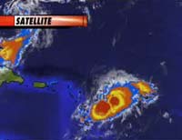
Tropical Storm Chris brushed past islands in the eastern Caribbean early Wednesday, and forecasters said the third named storm of the Atlantic hurricane season could strengthen into a hurricane later in the day.
The storm had top sustained winds of nearly 60 mph as it passed over the northernmost Leeward Islands and was expected to gather strength as it moved west-northwest in the direction of the
Virgin Islands, according to the U.S. National Hurricane Center in Miami.
Long-range forecasts put the storm anywhere from south of Cuba to Florida by late in the weekend. To be a
hurricane, the storm must reach sustained winds of at least 74 mph, a strengthening forecasters said could happen late Wednesday or Thursday.
A tropical storm warning remained in effect for St. Barthelemy, St. Maarten, Puerto Rico and the U.S. and British Virgin Islands. Tropical storm warnings for Antigua and Barbuda, Anguilla, St. Kitts and Nevis were discontinued.
As skies darkened and rain began to fall, people began the familiar ritual of stocking up on gas, food and candles. Tourists at a resort just outside the Antiguan capital said they had no plans to evacuate.
http://www.foxnews.com/story/0,2933,206655,00.html
MIAMI, Aug 2 (Reuters) - The Bahamas on Wednesday issued a hurricane watch for the Turks and Caicos islands and for the southeastern Bahamas as Tropical Storm Chris neared hurricane strength in the Caribbean, the U.S. National Hurricane Center said.
The maximum sustained winds of the third tropical cyclone of the 2006 Atlantic hurricane season were at 65 mph (100 kph) by 11 a.m. EDT (1500 GMT), the center said.
Chis Update
 ST. JOHN'S, Antigua — Tropical Storm Chris brushed past islands in the eastern Caribbean early Wednesday, and forecasters said the third named storm of the Atlantic hurricane season could strengthen into a hurricane later in the day.
The storm had top sustained winds of nearly 60 mph as it passed over the northernmost Leeward Islands and was expected to gather strength as it moved west-northwest in the direction of the Virgin Islands, according to the U.S. National Hurricane Center in Miami.
Long-range forecasts put the storm anywhere from south of Cuba to Florida by late in the weekend. To be a hurricane, the storm must reach sustained winds of at least 74 mph, a strengthening forecasters said could happen late Wednesday or Thursday.
A tropical storm warning remained in effect for St. Barthelemy, St. Maarten, Puerto Rico and the U.S. and British Virgin Islands. Tropical storm warnings for Antigua and Barbuda, Anguilla, St. Kitts and Nevis were discontinued.
As skies darkened and rain began to fall, people began the familiar ritual of stocking up on gas, food and candles. Tourists at a resort just outside the Antiguan capital said they had no plans to evacuate.
http://www.foxnews.com/story/0,2933,206655,00.html
MIAMI, Aug 2 (Reuters) - The Bahamas on Wednesday issued a hurricane watch for the Turks and Caicos islands and for the southeastern Bahamas as Tropical Storm Chris neared hurricane strength in the Caribbean, the U.S. National Hurricane Center said.
The maximum sustained winds of the third tropical cyclone of the 2006 Atlantic hurricane season were at 65 mph (100 kph) by 11 a.m. EDT (1500 GMT), the center said.
Chis Update


0 Comments:
Post a Comment
<< Home